

Earlier this year, India surpassed China to become the most populous country in the world. And with 68% of the world’s population projected to live in urban areas by 2050, India is expected to see an additional 416 million urban dwellers. As India gears up for the next decadal census, it is critical to ensure that ”urban” is defined and measured accurately and effectively.
In India, urban is defined conservatively, as the definition is based on criteria formulated in 1961. Post-Independence, India was largely a rural economy experiencing social, political and economic turmoil. Consequently, the agricultural sector was accorded priority to further develop the newly minted state. In this socioeconomic backdrop, the criteria chosen to delineate rural and urban areas were intended to prevent inflation of the country’s urbanization to prevent the diversion of funds away from the priority sector, agriculture.
However, India today is the fifth largest economy in the world, and its socioeconomic landscape is changing – with cities emerging as the loci of economic growth. The urban-rural classification is the cornerstone for policy and program design, development planning, financial allocation, administrative and governance systems, and research in India. An inadequate definition and methodology for measuring urbanization may lead to unplanned development, misallocation of funds and inaccurate provisioning of public goods and services.
India’s Current Definition of Urban
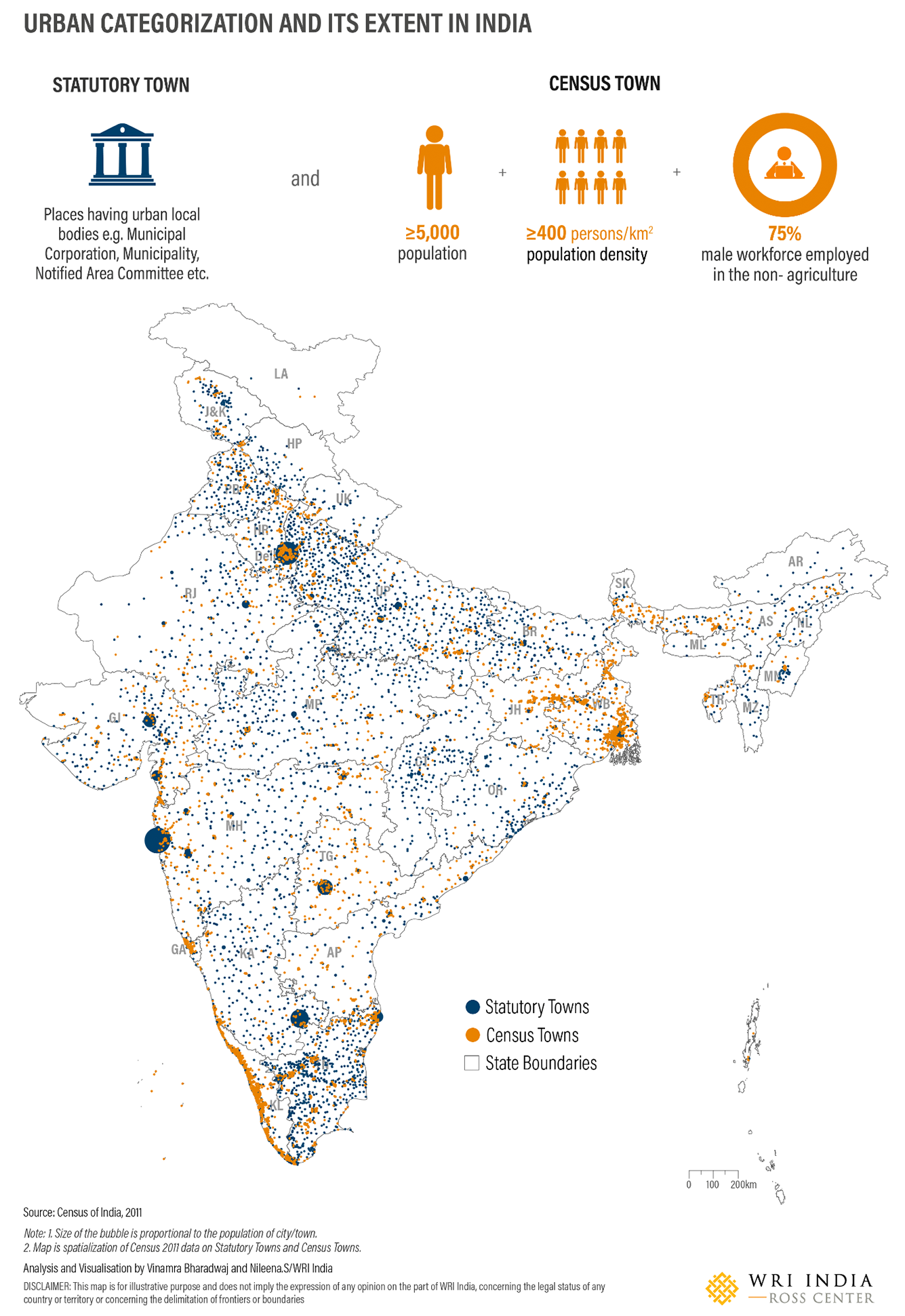
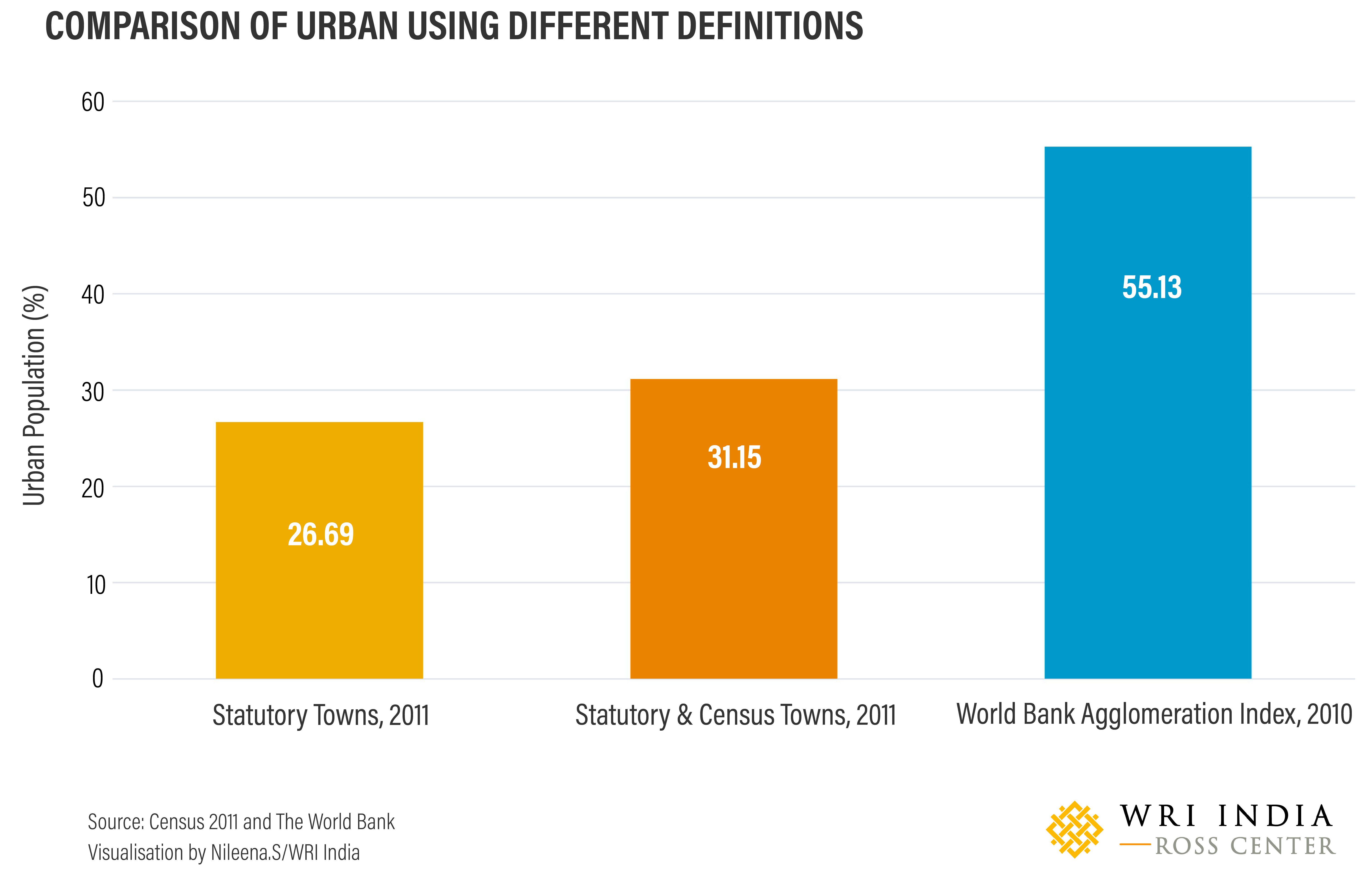
The Office of the Registrar General of India recognizes urban administrative units such as municipal corporations, municipalities, cantonment boards or notified town area committees as ”statutory towns”. Additionally, all other places that satisfy all three criteria – minimum population of 5000, population density greater than 400 persons per square kilometer and 75% male non-agricultural working population – are classified as ”census towns”. In the past, states in India have been encouraged by the Central Government to convert census towns to statutory towns. By current definition, only 31.2% of India is considered urban, and it has been strongly argued that this is less than the actual scale of urbanization.
This definition of urban used in India is considered particularly restrictive because it considers all three criteria – population size, population density and economic parameters. Most countries follow just one or two criteria, typically ranging from administrative, demographic, density (population and built-up) and economic activity to physical characteristics and levels of infrastructure.
The World Bank, using an alternative global method to measure urbanization known as the Agglomeration Index, observed that the “share of India’s population living in areas with urban-like features in 2010 was 55.3%.” This indicates that hidden or missing urbanization is unfolding on the peripheries of major cities or falls outside of the administrative boundaries of current statutory towns. This method, however, could not be scaled up for global use, as it relies on population size, population density and commuting time to the nearest large urban center; and consistent and comparable commute data is not available at a global scale.
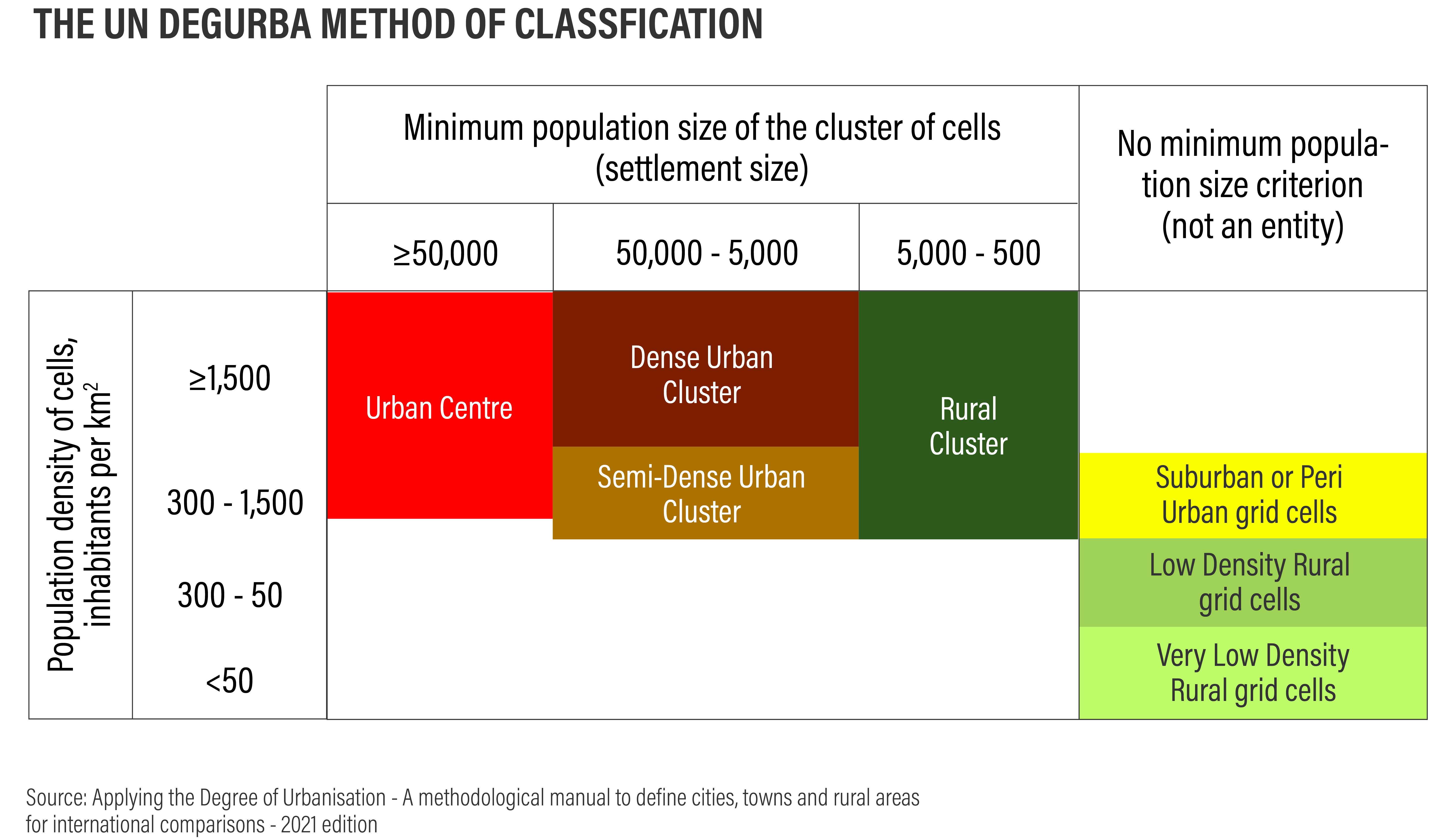
Degree of Urbanization: Global Definitions of “Cities”, “Urban” and “Rural”
Currently, there is no standard global definition of urban. The lack of a harmonized definition makes it difficult to conduct cross-national comparisons and learnings about the extent of urbanization, performance of urban areas, Sustainable Development Goal indicators, level of development and effectiveness of policies, among others. To address this problem, six international organizations – the EU, FAO, ILO, OECD, UN-Habitat and World Bank, collectively developed a harmonized method for delineation of cities, urban and rural areas, known as Degree of Urbanization (DEGURBA). DEGURBA was endorsed by the UN Statistical Commission at the 51st session held in March 2020 as the recommended method for international and regional statistical comparisons of urbanization.
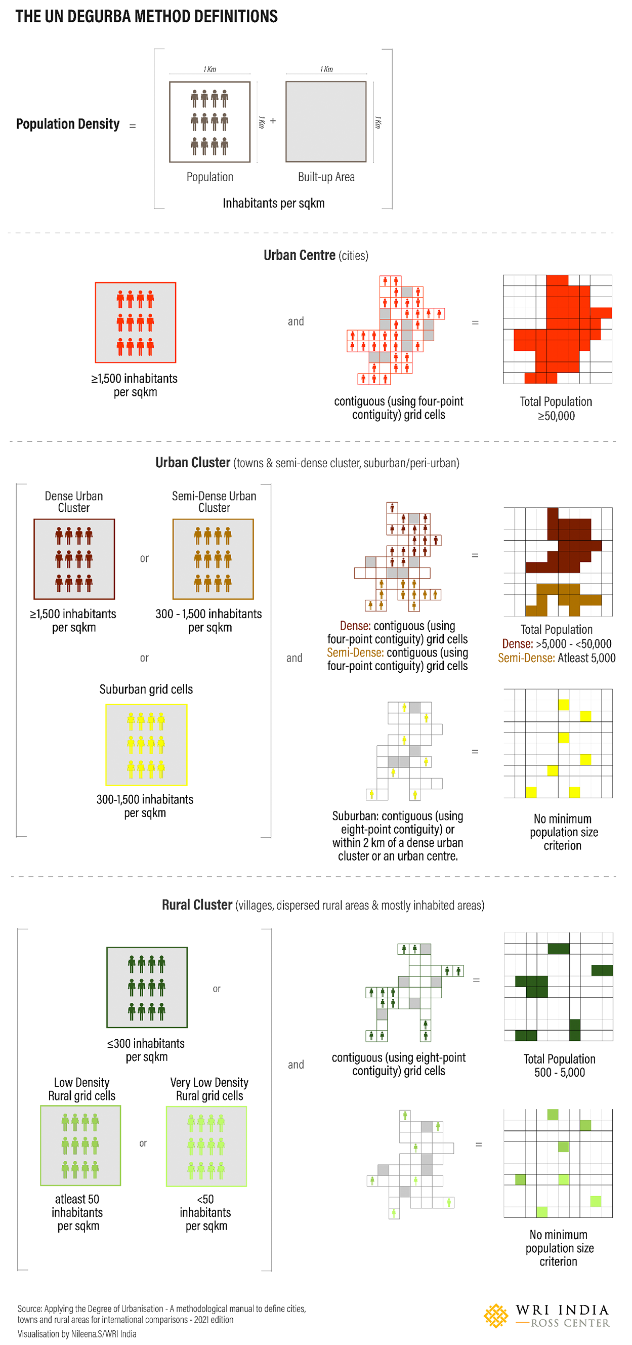
DEGURBA uses high-resolution satellite imagery to classify the entire territory of a country into three broad classes and seven sub-classes:
- Urban center
- Urban cluster with sub-classes of dense urban cluster, semi-dense urban cluster and suburban or peri-urban cells
- Rural areas with sub-classes of rural clusters, low-density rural grid cells and very low-density rural grid cells
This method provides seven sub-categorizations of settlements as compared to the two categorizations of urban and rural employed by the Census of India. This could potentially provide an enhanced understanding of a settlement’s characteristics, detect problems and aid in financial resource targeting post-testing of the method for India.
This method recognizes the true spatial extent of urban agglomerations by using population grids of 1 km2, rather than being restricted by the variable size of statistical and administrative boundaries. The DEGURBA approach captures the spatial concentration of people directly by combining built-up area and census population into pixel data. Broadly, this method recognizes areas that are more suitable for monitoring access to services and infrastructure based on varying population sizes and densities.
Limitations of the DEGURBA method include a very low urban density threshold which can result in the classification of entire cropland regions, as well as more lightly populated fringe areas of cities, as urban. Additionally, since it is based on an algorithm and machine learning, there are certain limitations such as under- or over-detection of the built-up area, lack of differentiation between different types of built-up areas and inclusion of the inaccuracies inherited from base data sources.
As India gears up to conduct its Census enumeration, despite its limitations, alternatives like the DEGURBA method merit attention – as it goes beyond the urban-rural dichotomy. Researchers at WRI India are currently testing this approach and plan to share findings in a working paper on the DEGURBA method’s relevance and adaptability to the Indian context.
This article originally appeared on WRI-India.org.
Sudeshna Chatterjee is Program Director of Sustainable Cities & Transport at WRI India.
Raj Bhagat Palanichamy is Senior Program Manager of GeoAnalytics for Sustainable Cities & Transport at WRI India.
Rejeet Matthews is Program Director of Urban Development at WRI India.
Shahena Khan is a Consultant with the Sustainable Cities & Transport program at WRI India.

