

Posts tagged with 'open source'

Just before she took office in January 2020, Mayor Claudia López committed to redesigning a major artery of Bogotá into a “green corridor” for sustainable, active mobility. She also committed to a comprehensive participatory planning process – a potentially daunting ...

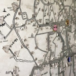
Hand-drawn in black marker and spanning an entire wall of Addis Ababa’s Anbessa company headquarters is a map depicting stops, timetables and fares for the city’s 73-year-old public bus system. Peeling icons and stickers tell a history of corrections and ...

WRI recently announced a partnership with OpenAQ and Development Seed to help more users access – and contribute to – air quality data from around the world through the OpenAQ open source platform. This update, which originally appeared on OpenAQ’s ...

After completing two successful Transportation Camp events in 2011 (in San Francisco and New York City), OpenPlans, a nonprofit technology organization, is hosting this year’s Transportation Camp in Washington, D.C. this weekend. OpenPlans is behind some of the greatest intersections ...

Escuelab, Softwin, Social Media Group and Development Seed are hosting an Open Data event in Lima, Peru Saturday, August 13, 2011. The event, “Open Data Meetup Lima,” is a day of sharing ideas, activities and workshops related to open data ...
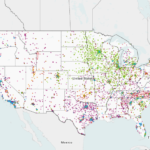
Today, the U.S. Department of Energy released an interactive map displaying thousands of alternative fuel stations around the nation, as part of a complete overhaul of Energy.gov. Color-coded points represent various alternative fuel sources, including electric and hydrogen stations. In ...

The Alliance for Biking and Walking is partnering with the Street Plan Collaborative to strengthen the expanding Open Streets movement. Making use of roadways in creative and active ways by closing streets to automobiles and allowing residents to walk, bike, ...

The National Building Museum held its Intelligent Cities Forum yesterday, an all-day event that brought together experts from across the United States to explore the evolving, deep-rooted connections between technology and cities. The event covered topics ranging from education and ...
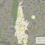
Above is an image of areas in the Columbia Heights neighborhood in Washington, D.C., specifically at Meridian Street and 14th Street, that are accessible within 15 minutes, thanks to a new mapping tool called Mapnificent, powered by Google Maps. Mapnificent is less ...
We wrote about Smarter Cities before, here and here, explaining how the new Web site ranks U.S. cities across categories like transportation and water quality, and also offering suggestions for how NRDC, the creators of the site, should “rebalance its ...

