

Posts tagged with 'maps'

Via the blog, SupraGeography, written by Oliver O’Brien, a researcher and software developer at the Centre for Advanced Spatial Analysis (CASA), TheCityFix came across wheelmap.org. It’s a website (and iPhone app) built to display and aggregate information on wheelchair access in ...

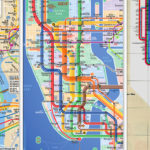
New York’s Metropolitan Transportation Authority is set to release a revamped subway map – the first since 1998. The new map features a taller and fatter Manhattan and a shrunken Staten Island; brighter, cheerier colors; and pared-down bus-connection bubbles. The ...

Our friends at SeeClickFix announced today that they have joined forces with The Washington Post, which now features a SeeClickFix widget on a new local news section called The Daily Gripe. The Post editors will highlight a “Gripe of the ...

As I noted in a post a little over a week ago, my SeeClickFix report about a dangerous pedestrian crossing at U Street and Florida Ave. NW has garnered a lot of attention, even surpassing my own expectations about the ...

The Washington Post reported Monday that Prince George’s County is updating its 25-year-old transportation master plan to include an extension of the Metro Green line, the proposed Purple line, and consideration of high-occupancy toll lanes on County highways. According to ...

TheCityFix DC talks a lot about how we’d like to see D.C. change. We’re also committed to making sure that your voices get heard. That (and the similar names!) is why we’ve teamed up with SeeClickFix to try and spread ...
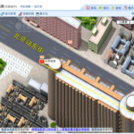
For foreigners moonlighting in Beijing like myself, navigating the concrete jungle of China’s capital can be quite intimidating. Never to fear: The Beijing edition of E都市 (“E-dushi,” which essentially translates as “E-Metropolis”) is an innovative map providing satellite, two- and ...

Art by Philip Straub, via National Geographic. In its latest issue, National Geographic shows what the now bustling urban jungle of Manhattan looked like before Henry Hudson spotted the island in 1609. Four hundred years ago, there were beavers, just ...
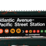
The news is a few days old, but I think it’s really fascinating that New York is considering selling partial naming rights to the Atlantic/Pacific station, the second busiest station in Brooklyn. The Times article on the sale gives some ...

Just in time for Earth Day last week, Cisco IBSG and San Francisco’s Department of the Environment unveiled Urban EcoMap, a Web-based tool that “provides urban communities with relevant data regarding the primary [greenhouse gas] contributors—transportation, waste, and energy.” Working ...

